Today's walk was beautiful but difficult! We left Cercedilla about 8 am. After a coffee at the train station, we headed up up up the road.
We ate breakfast at a picnic area along the way then continued on.
Soon we were in the park and pines.
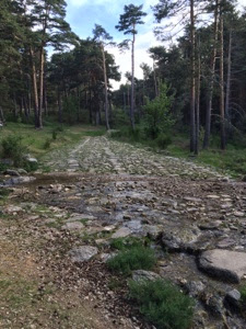
And soon the Roman road was in front of us.
And soon the Roman road was in front of us.
Read the kiosks. There are several trails up the mountain. All reach the exact same place. Each trail is marked with colored dots on the trees. The actual Camino follows a very rocky, steep path in places and so we chose to follow the green dots, called the Roman road. The path was good dirt and easy to follow.
There were places where several yellow arrows would suggest a route that would turn into a rock scramble. Instead, we continued on the green dot path and did fine.
It was beautiful but steep hard walking.
All along the way were small maps on kiosks. Pay attention to these especially as you begin reaching the top. Sometimes a trail would appear to go off on one direction but the map would indicate another way. The map proved to be right each time.
There was at least one place we saw this white and yellow 'x'. Usually this indicates do not go this way but in this case there would be a green dotted tree so we continued on. This must mean 'not the Camino trail' but since we were following a different trail, we ignored the 'x.'
It got steeper toward the top but was not as bad as expected. If you have done SJPP to Orisson or the O Cebreiro stretch, this was a piece of cake in comparison.
Well, maybe a piece of BIG cake!
We saw deer, hawks, and horses.
At the top we stopped for lunch.
As you are facing the Camino, which will be an asphalt road straight ahead, there is also a road going off to the right. The fountain is about 50 yards down that road.
We counted two other good fountains on the way down. They did not indicate they were potable but several local bicycle dudes were drinking and told us the water was very good!
There are many places where you can choose to walk the road. The road could be an easier walk if you don't mind the asphalt. The Camino tends to take you up and down hills.
Up this path a ways is another fountain. It is small and easy to miss. It is on the right and is marked 'Fuente Romano.' I believe this is also good potable water.
When we came to way mark indicating 591 k to Santiago, we turned off the Camino and took the road to Valsain. We met a group of students here who were training to be park rangers. They were very helpful.
One said it was 3 kilometers to Valsain but in reality it was more like 5 or 6! Joe and I laughed and said we felt it was 3k until you could SEE Valsain! These roads seem to go on forever.
I didn't take photos because by now, I'm exhausted.
In fact, I think I may have been crying.
So it is 8 kilometers UP to the top , 8 kilometers DOWN to where you turn off, and another 5 to Valsain for 21k instead of 31 to Segovia. Here is a photo of that place. You have come mostly out if the pines into a second or third meadow and this choice is before you. For Valsain, take the asphalt road to the right.
Again, this is the same road you have repeatedly crossed on your way down, so if you are exhausted you could just walk this road. No vehicles pass this road except forest personnel so there is no traffic to speak of.
By the way, there is no sign indicating Valsain at this 'Y' - you simply take the asphalt road.
As you near Valsain, you will come to the top of a hill. There is another Y in the road with a dirt road going off left BUT YOU MUSt STAY RIGHT on the asphalt road.
The asphalt continues to the right down and around a horse ranch. Keep walking down down down. You will begin seeing Valsain to your right.
Keep walking until you get to a small road going off to the right. I can't recall if it is dirt or gravel or asphalt but it almost feels like a driveway for another horse farm you will see there. It passes the horse farm and turns into dirt. By now I was praying I wouldn't have to find my way clear over to the highway I saw in the distance.
My prayers were answered! At the edge of a hill the road goes sharply down and dumps you right in an old dusty plaza, Plaza Valsain. There is a bar and panaderia there although they appeared to be closed.
Find a bench and wait. The bus to Segovia picks you up right in that square in front of this building. See photo.
Buy your ticket from the driver. Our bus arrived at 4:25 pm and we went to the Estacion de autobuses in Segovia. Here is the current schedule.
We took a taxi to Hostal Natura for about 3,75 euro.
Dinner was pinchos and now it is bedtime.
Tomorrow is a rest day.
We are pooped!


What a day!! The rocky, steep trail (Camino) you describe sounds like many of the hiking trails I’ve been on. From the photos you posted, it looks like it was also a vey beautiful walk!! Good job!!
ReplyDeleteBeautiful photos. Thank you!
ReplyDeleteGood going!
By the way, I will NEVER again stay in Hostal Natura! Never! Not a good place.
ReplyDelete